Siem Reap Province (Siem Reap)
Siem Reap province is the tenth largest province in Cambodia. Having reached a population of one million in 2019, it ranks as the nation's fourth most populous province. A large portion of Siem Reap province's southern border is demarcated by the Tonle Sap and as such, it is one of the nine provinces that making up the Tonle Sap Biosphere Reserve. In modern times the province is best known as the site of Angkor and the Angkor Wat temple ruins, a UNESCO World Heritage Site. It is also the home of Banteay Srei, Roluos (temples), the UNESCO tentative site of Beng Mealea, and the UNESCO tentative site of Phnom Kulen National Park, home to the country's largest reclining Buddha.
The name Siem Reap literally means 'Siam defeated', a reminder of the centuries-old conflict between the Siamese and the Khmer. In Siam, the province and its capital were called Siemmarat (เสียมราฐ), literally meaning 'Siam's territory'.
Map - Siem Reap Province (Siem Reap)
Map


Country - Khmer_Republic
 |
 |
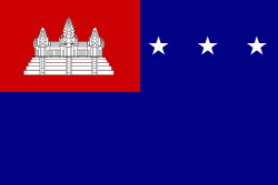
| Flag of Cambodia | |
The main cause of the coup was Norodom Sihanouk's tolerance of North Vietnamese military activity within Cambodia's borders; Vietnamese communist forces had gained de facto control over vast areas of eastern Cambodia as a result. Another important factor was the dire state of the Cambodian economy, an indirect result of Sihanouk's policies of pursuing neutrality.
Currency / Language
| ISO | Currency | Symbol | Significant figures |
|---|---|---|---|
| KHR | Cambodian riel | ៛ | 2 |
| ISO | Language |
|---|---|
| KM | Central Khmer language |
| EN | English language |
| FR | French language |